California Coast Road Trip: Plan Big Sur Without Backtracking
A practical California coast route explaining how to avoid backtracking, choose Big Sur bases and prepare for Highway 1 closures, fuel gaps and weak signal.
By Ceylon Trends · · 6 min read
The efficient way to drive the California coast is a one-way trip with changing overnight bases, not a series of out-and-back drives from one city. For the classic central-coast section, arrive in San Francisco and depart from Los Angeles—or reverse the direction—then place Big Sur between Monterey or Carmel and Cambria or San Luis Obispo.
That simple structure prevents hours of backtracking. It also needs a fallback because Highway 1 is vulnerable to landslides, storm damage and temporary closures. Never assume the road is continuous because an itinerary published months ago says so. Check Caltrans conditions shortly before booking nonrefundable details, again before departure and every morning around Big Sur.
Build a one-way route
A comfortable first route is:
- San Francisco: two or three nights. Do not collect a rental car until the morning you leave if you will not use it in the city; parking can be expensive and a parked car with visible property is a theft risk.
- Monterey or Carmel: one night. This creates time for Monterey Bay, Point Lobos or the northern approach to Highway 1 without rushing from San Francisco into a long scenic day.
- Big Sur corridor: two nights. A two-night stay creates one full day when you are not packing, checking out and driving to the next city.
- Cambria or San Luis Obispo: one night. This breaks the journey after the southern Big Sur coast and positions you for Morro Bay, wine country or the next section.
- Santa Barbara: one or two nights. It provides a genuine stop before Los Angeles rather than treating the whole coast as a driving exercise.
- Los Angeles: two or more nights. Return the car according to the rest of the trip; having one may still be useful depending on the neighborhoods you choose.
Reverse the list if northbound flights and rental prices work better. Southbound driving puts coastal pullouts on the ocean side of the highway, but road status, daylight and a sensible pace matter more than direction.
See the United States place guide and our New York first-time visitor plan for a contrasting city-based American itinerary.
Check Highway 1 closures correctly
Use the Caltrans highway-conditions tool and District 5 updates for the central coast. Enter highway number 1 and read the locations carefully. A closure “near Big Sur” can divide the road even while businesses and parks remain accessible from one side.
Then answer three questions:
- Can you drive completely between Carmel and Cambria on Highway 1?
- If not, which attractions and lodgings remain reachable from the north or south?
- Does the alternative route fit the same day, or must the overnight plan change?
A navigation app may eventually route around a closure, but it is not the authority on reopening dates, safe access or construction controls. Avoid unofficial back roads offered as shortcuts. They may be gated, unsuitable for rental cars, dangerous in bad weather or disruptive to residents.
If Highway 1 is severed, the practical inland connection is usually via major highways such as US 101, with details depending on the closure. Do not attempt to “complete” Big Sur from both sides in one day. Instead, choose a northern Big Sur experience from Carmel or Monterey, take the official inland detour on a separate travel leg and continue the coast from Cambria. This preserves useful time without repeated driving.
Pick bases by what is open
Monterey has a larger choice of services and suits aquarium and Cannery Row plans. Carmel-by-the-Sea places visitors closer to Point Lobos and the northern coast, with a compact center but often higher room prices.
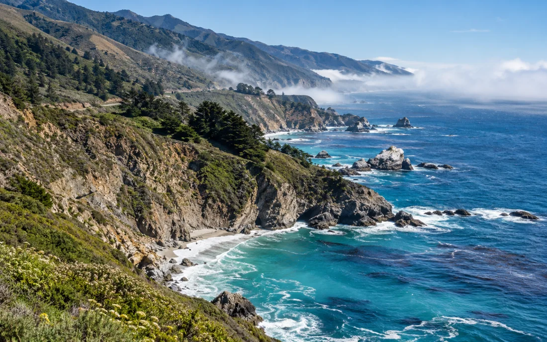
Staying within the Big Sur corridor reduces commuting and lets you experience early and late light, but lodging is limited, cell service is weak and prices can be high. Confirm which direction can reach the property when closures exist. Never interpret “Big Sur is open” as proof that through-driving is possible.
Cambria is a calm southern base near coastal viewpoints, while San Luis Obispo offers more restaurants and inland connections. Choose based on the following day's route, not just tonight's room price.
Campers need advance planning. California State Parks warns that Pfeiffer Big Sur is extremely popular and reservations can fill months ahead. Park, campground, trail and fire status can change independently of the highway, so check the relevant park page instead of assuming road access means every facility is operating.
Fuel, signal and rental-car preparation
Start the Big Sur driving day with a generous fuel margin. Fuel exists in the region but locations are limited and prices can be high; do not plan around reaching the final few miles of the tank. Fill in Monterey/Carmel or Cambria/San Luis Obispo depending on direction.
Download offline maps while connected to Wi-Fi and save the lodging address, confirmation and phone number. California State Parks advises that cell service is extremely limited in Big Sur. A paper overview map is also useful because an offline phone can still fail, overheat or lose power.
Carry drinking water, food for a delay, a charging cable and warm layers. Coastal temperatures can change quickly, and fog or rain can reduce visibility. Inspect the rental agreement for additional-driver, toll, mileage and roadside-assistance terms. Photograph existing vehicle damage at collection.
Never leave luggage, passports or electronics visible in a parked car. On a moving road trip, full concealment is not always possible, so transfer baggage directly to lodging before urban sightseeing whenever practical. A covered trunk reduces visibility but is not a guarantee.
Design a Big Sur day with priorities
Big Sur is a landscape corridor, not a single attraction. Choose a small number of anchors and accept that parking, weather and access may alter them.
A north-to-south day might prioritize:
- Point Lobos or another substantial morning walk;
- Bixby Creek Bridge viewed only from a legal, safe pullout;
- one redwood or river stop around Pfeiffer Big Sur;
- one waterfall, beach or state-park area whose current access is confirmed;
- unhurried viewpoints before reaching the night's base.
Do not stop in the travel lane, cross traffic impulsively or park beyond marked limits to recreate a photograph. If a pullout is full, continue. Drones face restrictions in parks and parts of the coast; check rules for the exact location.
Estimate progress in experiences, not highway miles. A short map distance can consume most of a day once overlooks, walks, road controls and meals are included. Avoid scheduling a fixed-time evening event far beyond Big Sur after a full sightseeing day.
When to go and when to change the plan
Spring can bring green hills and flowing waterfalls but also rain-related disruption. Summer offers long daylight yet often brings fog and heavy demand. Fall can be clear and pleasant, while winter storms can affect roads and trails. These are tendencies, not promises.
The best travel day is one with safe roads and enough daylight. Recheck weather and highway conditions before setting out. If authorities close a road, a park posts a hazard, or visibility becomes poor, use the inland route or wait. Travel insurance with appropriate trip-interruption and rental-car provisions may reduce the financial impact of a forced change; read exclusions rather than assuming all road closures qualify.
Mistakes that create unnecessary driving
Avoid booking every night in San Francisco and “doing Big Sur” as a day trip. Avoid spending one night in Big Sur while approaching from Los Angeles, then returning to Los Angeles the next day. Avoid collecting and returning the car at the same airport solely because the rate first displayed looks cheaper; compare one-way fees against fuel, parking and the lost day.
Most importantly, do not book an unbroken chain of nonrefundable stays before checking the road. Reserve scarce accommodation early where cancellation terms are reasonable, document the terms, and recheck conditions before those deadlines.
A coast road trip succeeds when it remains a coast trip even after conditions change. Use progressive bases, protect two nights for Big Sur, keep the inland alternative ready and let official road information—not an old social post—decide the route.
Questions and answers
How do you avoid backtracking on a California coast road trip?
Use a one-way open-jaw route, such as San Francisco to Los Angeles, and sleep progressively south or north instead of returning to the same city after Big Sur.
Where should you check Highway 1 closures?
Check Caltrans road conditions and Caltrans District 5 updates shortly before departure and again each driving day; do not rely on an old itinerary or map alone.
How many nights should you allow for Big Sur?
Two nights in or near the Big Sur corridor provide a useful full day between arrival and departure. Add time if hiking or slow scenic stops are central to the trip.